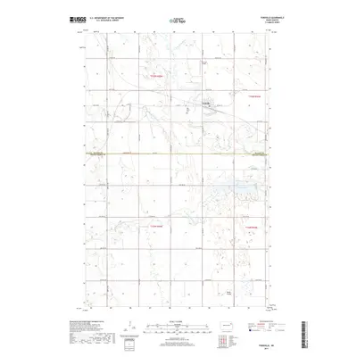
2017 Map of Fordville
USGS Topo · Published 2017About this map
Fordville sits at the heart of this agricultural landscape in the Red River Valley region, where the three branches of the Forest River converge. The town is flanked by its local infrastructure, including the Fordville Airport and the nearby Oak Grove Cem. This 2017 survey reveals the intricate water management of the area, anchored by the Fordville Dam on the main branch of the river. The terrain transitions between the flat till plains and the carved drainage of Skunk Coulee, while the land is neatly divided by an extensive network of rural roads such as Co Rd 19 and Co Hwy 19. This modern perspective captures the persistent grid of the Public Land Survey System, showing how the boundaries of Walsh and Grand Forks Counties dictate the local geography.
Find a feature on this map
43 named features on this map. Tap any name to fly to it.
Don’t see what you’re looking for? This feature index may not catch every label — zoom into the map to look around manually.
Map Details
Editions of this 2017 Fordville Map
This is the sole edition of this map. No revisions or reprints were ever made.
Other maps of this area

1952 · Thief River Falls
USGS Topo · 1:250,000

1956 · Thief River Falls
USGS Topo · 1:250,000

1957 · Thief River Falls
USGS Topo · 1:250,000

1963 · Orr
USGS Topo · 1:24,000

1963 · Pleasant Valley
USGS Topo · 1:24,000

1963 · Fordville SE
USGS Topo · 1:24,000

1963 · Pisek
USGS Topo · 1:24,000

1963 · Fordville
USGS Topo · 1:24,000
1963 · Inkster
USGS Topo · 1:24,000

1967 · Thief River Falls
USGS Topo · 1:250,000