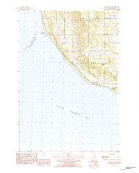
1983 Map of Forest Beach
USGS Topo · Published 1984About this map
Lake Michigan and the sheltered waters of Little Traverse Bay define this coastal portion of Emmet County, where the shoreline transitions from the prominent Sevenmile Point toward the residential pockets of the south. This early 1980s landscape is characterized by the townships of Friendship and West Traverse, showing a network of country lanes like Hughston Road and Middle Road that connect isolated properties to the waterfront.
Find a feature on this map
20 named features on this map. Tap any name to fly to it.
Don’t see what you’re looking for? This feature index may not catch every label — zoom into the map to look around manually.
Map Details
Editions of this 1983 Forest Beach Map
2 editions found
Other maps of this area

1955 · Cheboygan
USGS Topo · 1:250,000

1958 · Cheboygan
USGS Topo · 1:250,000

1958 · Cross Village
USGS Topo · 1:62,500

1958 · Pellston
USGS Topo · 1:62,500

1958 · Bayshore
USGS Topo · 1:62,500

1958 · Petoskey
USGS Topo · 1:62,500

1975 · Petoskey NW
USGS Topo · 1:24,000

1975 · Petoskey SW
USGS Topo · 1:24,000

1982 · Petoskey
USGS Topo · 1:100,000
1982 · Good Hart
USGS Topo · 1:25,000