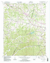
1994 Map of Forest Grove
USGS Topo · Published 1997About this map
The rolling highlands northwest of Nashville are defined here by a network of rural ridges and deep hollows, including Beech Hollow and the drainage of Sycamore Creek. This 1994 update reveals the convergence of historic transportation routes and mid-century suburban expansion, particularly around Joelton and the Interchange 31 corridor. The map documents a dense concentration of community centers that serve as vital landmarks for local genealogy, from the Gupton Cem to numerous small congregations like Mount Zion Ch and New Hope Ch.
Find a feature on this map
45 named features on this map. Tap any name to fly to it.
Don’t see what you’re looking for? This feature index may not catch every label — zoom into the map to look around manually.
Map Details
Editions of this 1994 Forest Grove Map
This is the sole edition of this map. No revisions or reprints were ever made.
Other maps of this area

1903 · Nashville
USGS Topo · 1:125,000

1930 · White Bluff
USGS Topo · 1:62,500

1931 · Ridgetop
USGS Topo · 1:62,500

1932 · Nashville
USGS Topo · 1:62,500

1933 · White Bluff
USGS Topo · 1:62,500

1935 · Ridgetop
USGS Topo · 1:62,500

1952 · Nashville West
USGS Topo · 1:24,000

1955 · Whites Creek
USGS Topo · 1:24,000

1955 · Forest Grove
USGS Topo · 1:24,000

1955 · Scottsboro
USGS Topo · 1:24,000