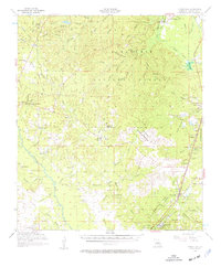
1956 Map of Forest Hill
USGS Topo · Published 1962About this map
Kisatchie National Forest and the Alexander State Forest dominate this mid-century landscape in Rapides Parish, where a network of lookout towers and timber-related sites define the local character. The survey documents the area's transition into a managed forest and military landscape, featuring the U S Air Force Military Reservation and landmarks like the Woodworth Lookout Tower. For genealogists, the map is a dense record of rural community life, preserving the locations of numerous country churches and cemeteries such as Amiable Ch and Union Hill Cem. Settlement patterns follow the Missouri Pacific railroad through Forest Hill and Woodworth, while the interior remains defined by creek-cut hills and scattered schools, including the St Mark Sch (Abandoned). The presence of the Valentine Recreational Area and a Boy Scout Camp highlights the growing importance of the pine woods for leisure and conservation.
Find a feature on this map
99 named features on this map. Tap any name to fly to it.
Don’t see what you’re looking for? This feature index may not catch every label — zoom into the map to look around manually.
Map Details
Editions of this 1956 Forest Hill Map
3 editions found

Other maps of this area

1932 · Boyce SW
USGS Topo · 1:31,680

1935 · Pawnee
USGS Topo · 1:31,680

1935 · Turkey Creek
USGS Topo · 1:62,500

1935 · Lecompte
USGS Topo · 1:62,500

1937 · Chopin SE
USGS Topo · 1:31,680

1941 · Alexandria
USGS Topo · 1:62,500

1941 · Boyce
USGS Topo · 1:62,500

1942 · Oakdale
USGS Topo · 1:62,500

1943 · Leander
USGS Topo · 1:62,500

1944 · Chopin
USGS Topo · 1:62,500