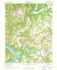
1968 Map of Forest Hill
USGS Topo · Published 1971About this map
Greenbrier River and New River converge in this landscape dominated by the winding curves of Big Bend Mountain and the expansive waters of Bluestone Lake. The terrain is marked by traditional ridge-and-valley settlements, including the community of Forest Hill and the historical resort area of Red Sulphur Springs. The map reveals a post-war rural infrastructure where several country churches, such as Mt Zion Ch and Bethlehem Ch, serve as local anchors for scattered farms and hollows like Dickinson Hollow.
Find a feature on this map
55 named features on this map. Tap any name to fly to it.
Don’t see what you’re looking for? This feature index may not catch every label — zoom into the map to look around manually.
Map Details
Editions of this 1968 Forest Hill Map
2 editions found
Other maps of this area

1887 · Hinton
USGS Topo · 1:125,000

1890 · Dublin
USGS Topo · 1:125,000

1891 · Dublin
USGS Topo · 1:125,000

1892 · Hinton
USGS Topo · 1:125,000

1912 · Big Bend
USGS Topo · 1:62,500

1913 · Peterstown
USGS Topo · 1:48,000

1914 · Big Bend
USGS Topo · 1:62,500

1916 · Peterstown
USGS Topo · 1:62,500

1921 · Alderson
USGS Topo · 1:48,000

1923 · Pearisburg
USGS Topo · 1:62,500