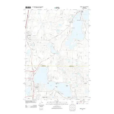
2013 Map of Forest Lake
USGS Topo · Published 2013About this map
The town of Forest Lake and the nearby settlement of Wyoming anchor this 2013 survey of the Minnesota lake country spanning the Chisago and Washington county line. The landscape is defined by its glacial hydrology, featuring a dense network of water bodies including Green Lake, Comfort Lake, and the expansive Forest Lake itself. This period shows significant suburban integration, with established residential areas like Bonnie Glen and Croix Estates situated alongside traditional recreation spots such as Timm's Marina and Campground.
Find a feature on this map
155 named features on this map. Tap any name to fly to it.
Don’t see what you’re looking for? This feature index may not catch every label — zoom into the map to look around manually.
Map Details
Editions of this 2013 Forest Lake Map
This is the sole edition of this map. No revisions or reprints were ever made.
Other maps of this area

1902 · White Bear
USGS Topo · 1:62,500

1948 · Stillwater
USGS Topo · 1:62,500

1949 · Stillwater
USGS Topo · 1:62,500

1952 · Centerville
USGS Topo · 1:24,000

1953 · Stillwater
USGS Topo · 1:250,000

1954 · Hugo
USGS Topo · 1:24,000

1955 · Marine
USGS Topo · 1:24,000

1955 · Forest Lake
USGS Topo · 1:62,500

1955 · Isanti
USGS Topo · 1:62,500
1955 · New Brighton
USGS Topo · 1:62,500