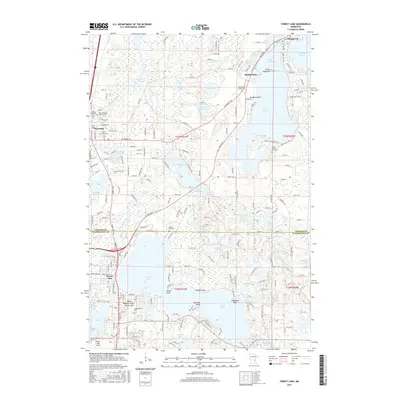
2016 Map of Forest Lake
USGS Topo · Published 2016About this map
Forest Lake and Chisago City define the landscape of this region, which is dominated by a dense network of interconnected glacial lakes and points. This 2016 survey captures the residential expansion around Green Lake, Comfort Lake, and the expansive Forest Lake itself, which spans the boundary between Chisago Co and Washington Co. The area’s spiritual and communal history is reflected in its numerous burial grounds, including the Scandinavian Cem near the southern shore and the cluster of United Methodist Cem, Saint Joseph's Catholic Cem, and Saint Pauls Cem near Wyoming. Transportation and infrastructure are anchored by the Forest Lake Airport and the Allina Medical Clinic, while landmarks like Simmons Point and Shadyland Point delineate the complex shorelines that have long drawn residents to these waters.
Find a feature on this map
194 named features on this map. Tap any name to fly to it.
Don’t see what you’re looking for? This feature index may not catch every label — zoom into the map to look around manually.
Map Details
Editions of this 2016 Forest Lake Map
This is the sole edition of this map. No revisions or reprints were ever made.
Other maps of this area

1902 · White Bear
USGS Topo · 1:62,500

1948 · Stillwater
USGS Topo · 1:62,500

1949 · Stillwater
USGS Topo · 1:62,500

1952 · Centerville
USGS Topo · 1:24,000

1953 · Stillwater
USGS Topo · 1:250,000

1954 · Hugo
USGS Topo · 1:24,000

1955 · Marine
USGS Topo · 1:24,000

1955 · Forest Lake
USGS Topo · 1:62,500

1955 · Isanti
USGS Topo · 1:62,500
1955 · New Brighton
USGS Topo · 1:62,500