
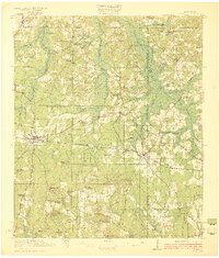
1922 Map of Forest
USGS Topo · Published 1922About this map
The town of Forest serves as the central hub of this 1920 survey, where the Alabama and Vicksburg RR intersects with a network of logging lines, including several branches of the Lumber RR. These rails supported a local economy deeply tied to the timber industry, reaching into the areas around Singleton Settlement and Derris Settlement. The landscape is a mosaic of small, family-named hills like Many Roads Hill and Harrell Prairie Hill, punctuated by an extensive system of rural schools and churches that defined early 20th-century social life. Notable community landmarks include the Patrons Union Campground and the village of Conehatta. The mapping details the headwaters of the Leaf River and numerous tributaries such as Bollybusha Creek, showing a transition from swampy lowlands to more elevated prairie terrain.
Find a feature on this map
80 named features on this map. Tap any name to fly to it.
Don’t see what you’re looking for? This feature index may not catch every label — zoom into the map to look around manually.
Map Details
Editions of this 1922 Forest Map
2 editions found
Other maps of this area

1921 · Forest
USGS Topo · 1:48,000

1922 · Morton
USGS Topo · 1:48,000

1924 · Morton
USGS Topo · 1:62,500

1950 · Forest
USGS Topo · 1:62,500

1951 · Morton
USGS Topo · 1:62,500

1952 · Forest
USGS Topo · 1:62,500

1953 · Meridian
USGS Topo · 1:250,000

1957 · Meridian
USGS Topo · 1:250,000

1961 · Carthage
USGS Topo · 1:62,500

1965 · Meridian
USGS Topo · 1:250,000