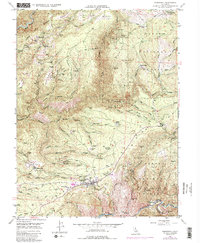
1949 Map of Foresthill
USGS Topo · Published 1987About this map
Gold-bearing ridges and deep river canyons characterize this mid-century survey of the California gold country, where the legacy of hydraulic and hard-rock mining is etched into the landscape. Foresthill serves as the primary hub, showing a Landing Strip and Ranger Station adjacent to the town center. The map details a high concentration of mineral claims and historical workings, from the California Morning Star Mine near Iowa Hill to the Mayflower Mine and Placer Diggings near Yankee Jims.
Find a feature on this map
90 named features on this map. Tap any name to fly to it.
Don’t see what you’re looking for? This feature index may not catch every label — zoom into the map to look around manually.
Map Details
Editions of this 1949 Foresthill Map
4 editions found
Other maps of this area

1891 · Colfax
USGS Topo · 1:125,000

1891 · Placerville
USGS Topo · 1:125,000

1892 · Placerville
USGS Topo · 1:125,000

1892 · Colfax
USGS Topo · 1:125,000

1893 · Placerville
USGS Topo · 1:125,000

1894 · Colfax
USGS Topo · 1:125,000

1898 · Colfax
USGS Topo · 1:125,000

1900 · Colfax
USGS Topo · 1:125,000

1902 · Colfax
USGS Topo · 1:125,000

1938 · Colfax
USGS Topo · 1:125,000