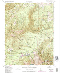
1949 Map of Foresthill
USGS Topo · Published 1987About this map
Foresthill and the ridge-top settlement of Iowa Hill define this landscape of gold-bearing gravels and steep river canyons. As of 1949, the area reflects a deep history of hydraulic and hard-rock mining, with active or historical sites such as the Mayflower Mine, Paragon Mine, and the California Morning Star Mine dotting the terrain between the North Fork American River and the Middle Fork American River. The presence of Yankee Jims and various diggings points to the early California Gold Rush roots of these communities, while the Hughes Mill and local ranch holdings like Ebberts Ranch suggest a diversifying economy in the mid-20th century. National forest boundaries for both the Tahoe National Forest and Eldorado National Forest converge here, emphasizing the transition from private mining claims to managed federal timber and recreation lands. Transportation is marked by rugged routes like the Shirttail Trail and a local Landing Strip near the town center.
Find a feature on this map
92 named features on this map. Tap any name to fly to it.
Don’t see what you’re looking for? This feature index may not catch every label — zoom into the map to look around manually.
Map Details
Editions of this 1949 Foresthill Map
4 editions found
Other maps of this area

1891 · Colfax
USGS Topo · 1:125,000

1891 · Placerville
USGS Topo · 1:125,000

1892 · Placerville
USGS Topo · 1:125,000

1892 · Colfax
USGS Topo · 1:125,000

1893 · Placerville
USGS Topo · 1:125,000

1894 · Colfax
USGS Topo · 1:125,000

1898 · Colfax
USGS Topo · 1:125,000

1900 · Colfax
USGS Topo · 1:125,000

1902 · Colfax
USGS Topo · 1:125,000

1938 · Colfax
USGS Topo · 1:125,000