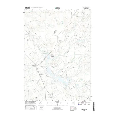
2016 Map of Forestport
USGS Topo · Published 2016About this map
Forestport and the surrounding Adirondack foothills are defined by the complex water system of the Black River and the expansive Kayuta Lake. This 2016 survey illustrates the modern configuration of the Forestport Reservoir and the network of waterways including Woodhull Creek and Little Woodhull Creek that converge in this northern Oneida County landscape. The map provides significant detail for genealogists, marking numerous historic burial grounds such as Beechwood Cem, Catholic Cem, and the French Road Church Cem near East Steuben. Small settlements like Woodhull, Honnedaga, and Alder Creek are connected by a mix of local roads and the N Country National Scenic Trail, reflecting a region where recreational land use and quiet residential pockets like Blue Waters Ests exist alongside the working infrastructure of the Boonville Inc Airport.
Find a feature on this map
103 named features on this map. Tap any name to fly to it.
Don’t see what you’re looking for? This feature index may not catch every label — zoom into the map to look around manually.
Map Details
Editions of this 2016 Forestport Map
This is the sole edition of this map. No revisions or reprints were ever made.
Other maps of this area

1897 · Remsen
USGS Topo · 1:62,500

1900 · Remsen
USGS Topo · 1:62,500

1904 · Boonville
USGS Topo · 1:62,500

1905 · Port Leyden
USGS Topo · 1:62,500

1907 · Port Leyden
USGS Topo · 1:62,500

1912 · Mc Keever
USGS Topo · 1:62,500

1940 · Port Leyden
USGS Topo · 1:62,500

1945 · Boonville
USGS Topo · 1:24,000

1945 · Forestport
USGS Topo · 1:24,000
1946 · Hinckley
USGS Topo · 1:25,000