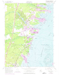
1953 Map of Forked River
USGS Topo · Published 1973About this map
The Barnegat Bay shoreline and the western pine forests meet in this detailed study of coastal Ocean County. The Central Railroad of New Jersey corridor and the Garden State Parkway anchor the north-south transit through Forked River and Waretown, while extensive residential dredging is visible at Sunrise Beach and Sands Point Harbor. A unique military presence is noted at the U S Navy Range Sta, positioned near the State Game Farm.
Find a feature on this map
49 named features on this map. Tap any name to fly to it.
Don’t see what you’re looking for? This feature index may not catch every label — zoom into the map to look around manually.
Map Details
Editions of this 1953 Forked River Map
3 editions found
Other maps of this area

1884 · Whitings
USGS Topo · 1:62,500

1888 · Barnegat
USGS Topo · 1:62,500

1888 · Little Egg Harbor
USGS Topo · 1:62,500

1888 · Long Beach
USGS Topo · 1:62,500

1888 · Whitings
USGS Topo · 1:62,500

1893 · Little Egg Harbor
USGS Topo · 1:62,500

1893 · Long Beach
USGS Topo · 1:62,500

1893 · Barnegat
USGS Topo · 1:62,500

1898 · Barnegat
USGS Topo · 1:62,500

1919 · Long Beach
USGS Topo · 1:62,500