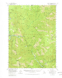
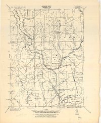
1955 Map of Forks of Salmon
USGS Topo · Published 1962About this map
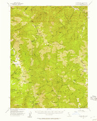
Forks of Salmon sits at the confluence of the north and south forks of the Salmon River, serving as a central point in this mid-century survey of the Klamath National Forest. The landscape is defined by its deep canyons and hydraulic mining history, evidenced by numerous named bars and flats along the riverbanks, including Knudsen Bar, Brazille Flat, and Fong Wah Bar. The presence of the Irving Creek Sch and Junction School alongside the Bennett Cem reflects the remote community life of Siskiyou County during this era. Mining activity remains a prominent feature of the local economy, with locations like the McNeal Mine, Evergreen Mine, and Sauerkraut Mine scattered across the steep drainages. High peaks such as Orleans Mtn and Tom Payne Peak tower over the Marble Mountain Wilderness boundary, where trails connect early camps like Camp Three and Bear Skull Camp.
Find a feature on this map
125 named features on this map. Tap any name to fly to it.
Don’t see what you’re looking for? This feature index may not catch every label — zoom into the map to look around manually.
Map Details
Editions of this 1955 Forks of Salmon Map
4 editions found
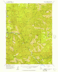
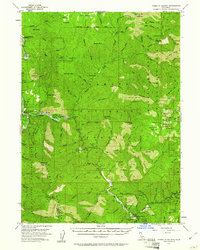
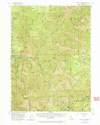
Other maps of this area

1914 · Seiad
USGS Topo · 1:125,000

1922 · Preston Peak
USGS Topo · 1:125,000

1922 · Seiad
USGS Topo · 1:125,000
1925 · Hoopa
USGS Topo · 1:125,000

1948 · Weed
USGS Topo · 1:250,000

1950 · Weed
USGS Topo · 1:250,000
1952 · Hoopa
USGS Topo · 1:62,500
1952 · Orleans
USGS Topo · 1:62,500
1955 · Dillon Mtn
USGS Topo · 1:62,500
1955 · Salmon Mtn
USGS Topo · 1:62,500