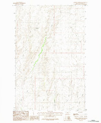
1984 Map of Forsman Reservoir
USGS Topo · Published 1984About this map
Forsman Reservoir sits at the heart of this Valley County landscape, surrounded by an intricate network of drainages that define the high plains of northern Montana. Published as a provisional map by the U.S. Geological Survey based on data from the mid-1970s, the sheet illustrates the critical role of water management in this arid region. The terrain is deeply incised by multiple watercourses, including Buggy Creek and Wolf Creek, which wind through the breaks and coulees.
Find a feature on this map
8 named features on this map. Tap any name to fly to it.
Don’t see what you’re looking for? This feature index may not catch every label — zoom into the map to look around manually.
Map Details
Editions of this 1984 Forsman Reservoir Map
This is the sole edition of this map. No revisions or reprints were ever made.
Other maps of this area

1919 · Boundary
USGS Topo · 1:125,000

1943 · Glasgow
USGS Topo · 1:125,000

1954 · Glasgow
USGS Topo · 1:250,000

1957 · Glasgow
USGS Topo · 1:250,000

1958 · Glasgow
USGS Topo · 1:250,000

1969 · Cornwell Reservoir
USGS Topo · 1:24,000

1969 · Chapman Coulee NE
USGS Topo · 1:24,000
1969 · Tampico NE
USGS Topo · 1:24,000

1984 · Laundry Hill
USGS Topo · 1:24,000

1984 · Opheim
USGS Topo · 1:100,000