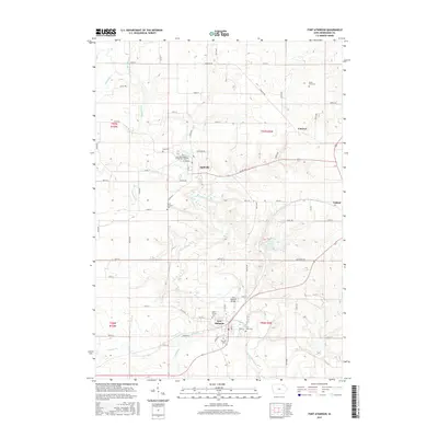
2015 Map of Fort Atkinson
USGS Topo · Published 2015About this map
The Turkey River winds through this portion of Winneshiek County, carving a valley that anchors several early Iowa settlements. In Spillville, the landscape is defined by its deep cultural roots, evidenced by the Saint Wenceslaus of Spillville Cem and historical connections to the river. Further south, the town of Fort Atkinson sits near the Fort Atkinson Bridge, surrounded by multiple burial sites including Saint Peters Cem and Saint Johns Cem. The region's geography is characterized by a network of drainage creeks like Bohemian Cr and Wonder Cr, which feed into the primary river system. To the east, the community of Calmar and the recreation area at Lake Meyer provide a contrast to the agricultural plateaus. This 2015 update preserves the locations of numerous family-named landmarks like Kruse Farm Cem, offering a detailed view of the rural township structure and its enduring local heritage.
Find a feature on this map
70 named features on this map. Tap any name to fly to it.
Don’t see what you’re looking for? This feature index may not catch every label — zoom into the map to look around manually.
Map Details
Editions of this 2015 Fort Atkinson Map
This is the sole edition of this map. No revisions or reprints were ever made.
Other maps of this area

1906 · Decorah
USGS Topo · 1:125,000

1954 · Mason City
USGS Topo · 1:250,000

1957 · Mason City
USGS Topo · 1:250,000

1958 · Mason City
USGS Topo · 1:250,000

1958 · La Crosse
USGS Topo · 1:250,000

1961 · La Crosse
USGS Topo · 1:250,000

1965 · La Crosse
USGS Topo · 1:250,000

1975 · Decorah 3 NW
USGS Topo · 1:24,000

1975 · Decorah 2 SW
USGS Topo · 1:24,000
1975 · Decorah 3 NE
USGS Topo · 1:24,000