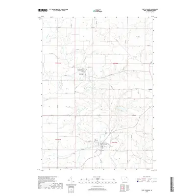
2018 Map of Fort Atkinson
USGS Topo · Published 2018About this map
The Turkey River winds through this section of Winneshiek County, carving a path between the established settlements of Spillville, Fort Atkinson, and Calmar. This landscape is deeply rooted in its Czech and German heritage, evidenced by the numerous religious sites and burial grounds such as Saint Wenceslaus of Spillville Cem and Saint Johns Cem. The settlement pattern follows the drainage of the river and its many tributaries, including Wonder Cr, Goddard Cr, and Krumm Cr, which define the local topography. At Fort Atkinson, the Fort Atkinson Bridge serves as a central landmark near the historic military site, while the small community of Conover remains a distinct point in the northern agricultural region. The concentration of family-named cemeteries like Kruse Farm Cem and Haug Cem indicates a long-standing continuity of land ownership in this part of northeastern Iowa.
Find a feature on this map
76 named features on this map. Tap any name to fly to it.
Don’t see what you’re looking for? This feature index may not catch every label — zoom into the map to look around manually.
Map Details
Editions of this 2018 Fort Atkinson Map
This is the sole edition of this map. No revisions or reprints were ever made.
Other maps of this area

1906 · Decorah
USGS Topo · 1:125,000

1954 · Mason City
USGS Topo · 1:250,000

1957 · Mason City
USGS Topo · 1:250,000

1958 · Mason City
USGS Topo · 1:250,000

1958 · La Crosse
USGS Topo · 1:250,000

1961 · La Crosse
USGS Topo · 1:250,000

1965 · La Crosse
USGS Topo · 1:250,000

1975 · Decorah 3 NW
USGS Topo · 1:24,000

1975 · Decorah 2 SW
USGS Topo · 1:24,000
1975 · Decorah 3 NE
USGS Topo · 1:24,000