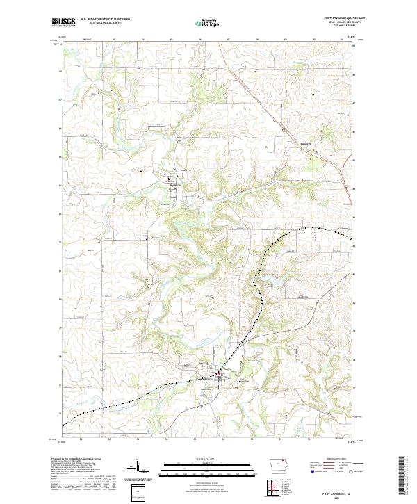
2022 Map of Fort Atkinson
USGS Topo · Published 2022About this map
Turkey River dominates this portion of Winneshiek County, carving a serpentine path through the landscape near the historic settlements of Fort Atkinson and Spillville. The map documents a deeply rooted agricultural and religious heritage, as evidenced by the numerous parish cemeteries including Saint Wenceslaus Cem and Saint Peters Cem. In the northeast, the Prairie Farmer Recreational Trl follows a former rail corridor through Conover toward Calmar, reflecting the transition of industrial transportation routes into modern recreational assets. Smaller tributaries like Wonder Cr and Bohemian Cr feed into the river system, defining the drainage patterns between the various range lines. This modern survey captures the enduring presence of family-named landmarks like Haug Cem and Kruse Farm Cem, which remain vital for genealogical research in this part of Iowa.
Find a feature on this map
64 named features on this map. Tap any name to fly to it.
Don’t see what you’re looking for? This feature index may not catch every label — zoom into the map to look around manually.
Map Details
Editions of this 2022 Fort Atkinson Map
This is the sole edition of this map. No revisions or reprints were ever made.
Other maps of this area

1906 · Decorah
USGS Topo · 1:125,000

1954 · Mason City
USGS Topo · 1:250,000

1957 · Mason City
USGS Topo · 1:250,000

1958 · Mason City
USGS Topo · 1:250,000

1958 · La Crosse
USGS Topo · 1:250,000

1961 · La Crosse
USGS Topo · 1:250,000

1965 · La Crosse
USGS Topo · 1:250,000

1975 · Decorah 3 NW
USGS Topo · 1:24,000

1975 · Decorah 2 SW
USGS Topo · 1:24,000
1975 · Decorah 3 NE
USGS Topo · 1:24,000