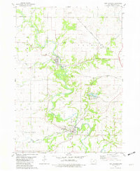
1981 Map of Fort Atkinson
USGS Topo · Published 1982About this map
Fort Atkinson and Spillville anchor this Winneshiek County landscape, centered on the winding course of the Turkey River during the early 1980s. The map highlights significant local history at the Fort Atkinson State Preserve, alongside several rural burial grounds such as St Johns Cem and St Peters Cem that serve as vital records for genealogists. The influence of the Chicago Milwaukee St Paul and Pacific railroad is evident as it cuts through the township of Calmar and past the settlement of Conover. Recreational development is well-established by this era, notably at Lake Meyer County Park, which features a Boat Ramp and Campground. The terrain is characterized by the confluence of numerous creeks, including Bohemian Cr and Wonder Creek, which feed into the primary river valley.
Find a feature on this map
34 named features on this map. Tap any name to fly to it.
Don’t see what you’re looking for? This feature index may not catch every label — zoom into the map to look around manually.
Map Details
Editions of this 1981 Fort Atkinson Map
This is the sole edition of this map. No revisions or reprints were ever made.
Other maps of this area

1906 · Decorah
USGS Topo · 1:125,000

1954 · Mason City
USGS Topo · 1:250,000

1957 · Mason City
USGS Topo · 1:250,000

1958 · Mason City
USGS Topo · 1:250,000

1958 · La Crosse
USGS Topo · 1:250,000

1961 · La Crosse
USGS Topo · 1:250,000

1965 · La Crosse
USGS Topo · 1:250,000

1975 · Decorah 3 NW
USGS Topo · 1:24,000

1975 · Decorah 2 SW
USGS Topo · 1:24,000
1975 · Decorah 3 NE
USGS Topo · 1:24,000