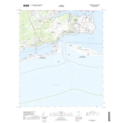
2018 Map of Fort Barrancas
USGS Topo · Published 2018About this map
NAS Pensacola and the sprawling Pensacola Naval Air Station/Forrest Sherman Field dominate the northern coast of the Pensacola Bay entrance. This military presence is anchored by the Barrancas National Cemetery and numerous support facilities connected by Radford Blvd and S Blue Angel Pkwy. Across the water, the northern tip of Santa Rosa Island is preserved as part of the Gulf Islands National Seashore, where the defensive works of Fort Pickens stand watch over Caucus Shoal. The geography is defined by complex shorelines including Bayou Grande and Sherman Inlet, providing critical access for the Intracoastal Waterway. To the west, residential areas like Pleasant Grove and Quinavista give way to the low-lying Garcon Swamp and the Red Bluffs overlooking Big Lagoon.
Find a feature on this map
57 named features on this map. Tap any name to fly to it.
Don’t see what you’re looking for? This feature index may not catch every label — zoom into the map to look around manually.
Map Details
Editions of this 2018 Fort Barrancas Map
This is the sole edition of this map. No revisions or reprints were ever made.
Other maps of this area

1921 · Pensacola
USGS Topo · 1:62,500

1921 · Fort Barrancas
USGS Topo · 1:62,500

1941 · Fort Barrancas
USGS Topo · 1:62,500

1941 · Pensacola
USGS Topo · 1:62,500

1942 · Pensacola
USGS Topo · 1:62,500

1943 · Fort Barrancas
USGS Topo · 1:62,500

1944 · Perdido Bay North
USGS Topo · 1:25,000

1944 · West Pensacola
USGS Topo · 1:25,000

1944 · Perdido Bay South
USGS Topo · 1:25,000

1944 · Gulf Breeze
USGS Topo · 1:25,000