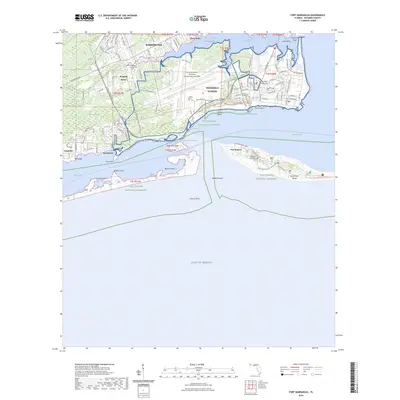
2024 Map of Fort Barrancas
USGS Topo · Published 2024About this map
The Pensacola Naval Air Station and the historic grounds of Fort Pickens dominate this coastal landscape at the entrance to Pensacola Bay. This 2024 edition highlights the complex military and maritime infrastructure surrounding Warrington and Mustin Beach, where the operational air station meets the protected lands of the Gulf Islands National Seashore. For those tracing local history, the map identifies several significant burial sites, including the Old Warrington National Cem, Pleasant Grove Cem, and the Chasefield Plantation Cem located on Santa Rosa Island. The area's intricate geography is defined by narrow waterways like Sherman Inlet and Redoubt Bayou, while small settlements such as Quinavista, Seaglades, and Pleasant Grove are interspersed among the low-lying terrain of the Garcon Swamp and the shores of Big Lagoon.
Find a feature on this map
67 named features on this map. Tap any name to fly to it.
Don’t see what you’re looking for? This feature index may not catch every label — zoom into the map to look around manually.
Map Details
Editions of this 2024 Fort Barrancas Map
This is the sole edition of this map. No revisions or reprints were ever made.
Other maps of this area

1921 · Pensacola
USGS Topo · 1:62,500

1921 · Fort Barrancas
USGS Topo · 1:62,500

1941 · Fort Barrancas
USGS Topo · 1:62,500

1941 · Pensacola
USGS Topo · 1:62,500

1942 · Pensacola
USGS Topo · 1:62,500

1943 · Fort Barrancas
USGS Topo · 1:62,500

1944 · Perdido Bay North
USGS Topo · 1:25,000

1944 · West Pensacola
USGS Topo · 1:25,000

1944 · Perdido Bay South
USGS Topo · 1:25,000

1944 · Gulf Breeze
USGS Topo · 1:25,000