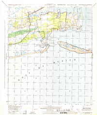
1944 Map of Fort Barrancas
USGS Topo · Published 1944About this map
Fort Barrancas and the surrounding coastal defenses dominate the entrance to Pensacola Bay in this mid-century military survey. The landscape is defined by its strategic naval and maritime infrastructure, including the Naval Air Sta, multiple battery locations, and an intricate network of navigation aids like the Pensacola Light House. The map captures the specialized environment of the Reservation Boundary, where military installations such as Fort Pickens on Santa Rosa Island and the now-isolated Fort Mcree guarded the narrow channel.
Find a feature on this map
37 named features on this map. Tap any name to fly to it.
Don’t see what you’re looking for? This feature index may not catch every label — zoom into the map to look around manually.
Map Details
Editions of this 1944 Fort Barrancas Map
This is the sole edition of this map. No revisions or reprints were ever made.
Other maps of this area

1921 · Pensacola
USGS Topo · 1:62,500

1921 · Fort Barrancas
USGS Topo · 1:62,500

1941 · Fort Barrancas
USGS Topo · 1:62,500

1941 · Pensacola
USGS Topo · 1:62,500

1942 · Pensacola
USGS Topo · 1:62,500

1943 · Fort Barrancas
USGS Topo · 1:62,500

1944 · Perdido Bay North
USGS Topo · 1:25,000

1944 · West Pensacola
USGS Topo · 1:25,000

1944 · Perdido Bay South
USGS Topo · 1:25,000

1944 · Gulf Breeze
USGS Topo · 1:25,000