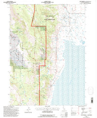
1993 Map of Fort Bidwell
USGS Topo · Published 1996About this map
Fort Bidwell sits at the edge of the Surprise Valley floor, where the Warner Mountains rise abruptly to the west. This 1993 revision, conducted by the U.S. Forest Service, highlights a landscape defined by water management and public lands. The Fort Bidwell Indian Reservation occupies the transition between the valley and the heights of the Modoc National Forest, containing local infrastructure like a Fish Hatchery and Sewage Ponds.
Find a feature on this map
32 named features on this map. Tap any name to fly to it.
Don’t see what you’re looking for? This feature index may not catch every label — zoom into the map to look around manually.
Map Details
Editions of this 1993 Fort Bidwell Map
2 editions found
Other maps of this area

1886 · Alturas
USGS Topo · 1:250,000

1892 · Alturas
USGS Topo · 1:250,000

1954 · Alturas
USGS Topo · 1:250,000

1958 · Alturas
USGS Topo · 1:250,000

1962 · Alturas
USGS Topo · 1:250,000

1962 · Davis Creek
USGS Topo · 1:62,500

1962 · Willow Ranch
USGS Topo · 1:62,500

1962 · Cedarville
USGS Topo · 1:62,500

1962 · Fort Bidwell
USGS Topo · 1:62,500

1965 · Alturas
USGS Topo · 1:250,000