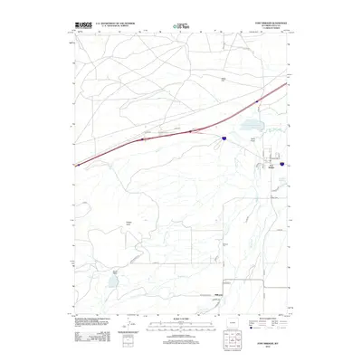
2012 Map of Fort Bridger
USGS Topo · Published 2012About this map
Fort Bridger stands as the primary anchor in this corner of Uinta County, surrounded by a complex network of historical irrigation and water management features. The landscape is defined by the braided channels of Blacks Fork and Little Blacks Fork, which support local agricultural efforts through the Center Ditch and the Bridger Butte Canal. Rising above the valley, Bridger Butte provides a prominent landmark overlooking the small settlement of Millburne to the south. This area, long essential for its position on western travel corridors, is documented here with its local infrastructure intact, from the Fort Bridger Cem and Millburne Cem to several local reservoirs like the Wall Development Company Reservoir and Erickson Reservoir. The map illustrates a rural Wyoming economy deeply tied to its water sources and the geographic prominence of the surrounding high plains.
Find a feature on this map
43 named features on this map. Tap any name to fly to it.
Don’t see what you’re looking for? This feature index may not catch every label — zoom into the map to look around manually.
Map Details
Editions of this 2012 Fort Bridger Map
This is the sole edition of this map. No revisions or reprints were ever made.
Other maps of this area

1954 · Ogden
USGS Topo · 1:250,000

1958 · Ogden
USGS Topo · 1:250,000

1960 · Ogden
USGS Topo · 1:250,000

1964 · Fort Bridger
USGS Topo · 1:24,000

1964 · Carter
USGS Topo · 1:24,000

1964 · Mountain View
USGS Topo · 1:24,000

1964 · Austin Reservoir
USGS Topo · 1:24,000
1964 · Leavitt Bench
USGS Topo · 1:24,000
1964 · Robertson
USGS Topo · 1:24,000

1965 · Bridger
USGS Topo · 1:24,000