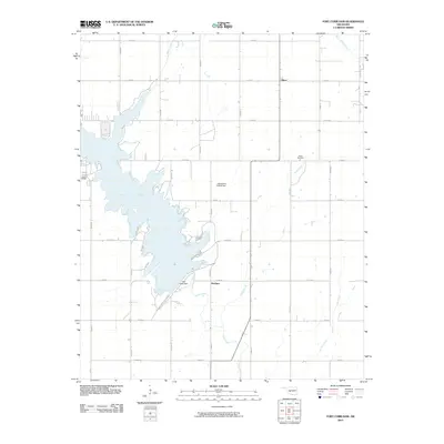
2010 Map of Fort Cobb Dam
USGS Topo · Published 2010About this map
Fort Cobb Reservoir dominates this Caddo County landscape, created by the engineering of the Fort Cobb Dam along Cobb Creek. This area of Oklahoma reflects a rural grid system where small, curiously named settlements like Nowhere and Albert provide localized landmarks within the agricultural expanse. The infrastructure of the reservoir is further detailed by the Oknoname 015018 Dam, while the surrounding terrain is defined by a network of drainage systems including Punjo Creek, Willow Creek, and Keechi Creek. Genealogists and local historians will find the Albert Cemetery documented in the northeast, serving as a point of reference for family roots in this prairie region. The map preserves the specific road network of the era, from section-line routes like E1220 Rd to north-south connectors such as N2550 Rd, illustrating the intersection of water management and rural life.
Find a feature on this map
28 named features on this map. Tap any name to fly to it.
Don’t see what you’re looking for? This feature index may not catch every label — zoom into the map to look around manually.
Map Details
Editions of this 2010 Fort Cobb Dam Map
This is the sole edition of this map. No revisions or reprints were ever made.
Other maps of this area

1951 · Binger
USGS Topo · 1:62,500

1951 · Fort Cobb
USGS Topo · 1:62,500

1955 · Clinton
USGS Topo · 1:250,000

1957 · Clinton
USGS Topo · 1:250,000

1961 · Eakly
USGS Topo · 1:62,500

1961 · Carnegie
USGS Topo · 1:62,500
1979 · Anadarko West
USGS Topo · 1:24,000

1979 · Sickles
USGS Topo · 1:24,000
1979 · Fort Cobb Dam
USGS Topo · 1:24,000
1979 · Binger
USGS Topo · 1:24,000