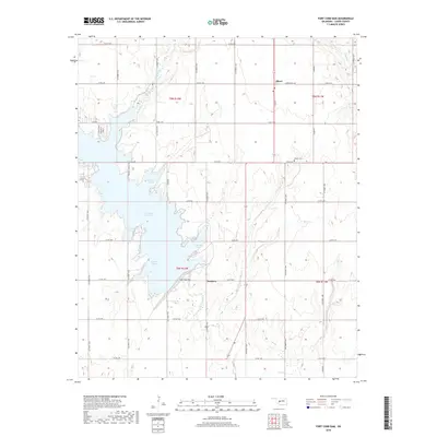
2018 Map of Fort Cobb Dam
USGS Topo · Published 2018About this map
Nowhere and Albert anchor this Caddo County landscape, situated just north of the extensive Fort Cobb Reservoir. The settlement of Albert is marked by its post office and the nearby Albert Cem, while the tongue-in-cheek named Nowhere sits near the eastern end of the Fort Cobb Dam. This 2018 survey reveals a modern rural environment where the hydrology of the Washita River basin is heavily managed for recreation and irrigation, evidenced by the distinct naming of various inlets like Carnegie Cove, Marina Cove, and Farmers Slough. The surrounding terrain is dissected by numerous drainages, including Keechie Cr, Willow Cr, and Punjo Cr, which flow through a grid of county roads that define the region's agricultural layout.
Find a feature on this map
33 named features on this map. Tap any name to fly to it.
Don’t see what you’re looking for? This feature index may not catch every label — zoom into the map to look around manually.
Map Details
Editions of this 2018 Fort Cobb Dam Map
This is the sole edition of this map. No revisions or reprints were ever made.
Other maps of this area

1951 · Binger
USGS Topo · 1:62,500

1951 · Fort Cobb
USGS Topo · 1:62,500

1955 · Clinton
USGS Topo · 1:250,000

1957 · Clinton
USGS Topo · 1:250,000

1961 · Eakly
USGS Topo · 1:62,500

1961 · Carnegie
USGS Topo · 1:62,500
1979 · Anadarko West
USGS Topo · 1:24,000

1979 · Sickles
USGS Topo · 1:24,000
1979 · Fort Cobb Dam
USGS Topo · 1:24,000
1979 · Binger
USGS Topo · 1:24,000