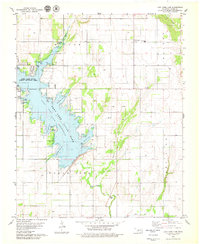
1979 Map of Fort Cobb Dam
USGS Topo · Published 1979About this map
The Fort Cobb State Reservoir dominates the western portion of this Oklahoma landscape, defined by its intricate shoreline featuring Carnegie Cove, Marina Cove, and the winding Kardokas Slough. The impoundment of this water body, regulated by the Dam, dramatically altered the local topography, creating extensive recreational and conservation zones within the Fort Cobb State Park and the adjacent Fort Cobb State Public Hunting Area.
Find a feature on this map
33 named features on this map. Tap any name to fly to it.
Don’t see what you’re looking for? This feature index may not catch every label — zoom into the map to look around manually.
Map Details
Editions of this 1979 Fort Cobb Dam Map
This is the sole edition of this map. No revisions or reprints were ever made.
Other maps of this area

1951 · Binger
USGS Topo · 1:62,500

1951 · Fort Cobb
USGS Topo · 1:62,500

1955 · Clinton
USGS Topo · 1:250,000

1957 · Clinton
USGS Topo · 1:250,000

1961 · Eakly
USGS Topo · 1:62,500

1961 · Carnegie
USGS Topo · 1:62,500
1979 · Anadarko West
USGS Topo · 1:24,000

1979 · Sickles
USGS Topo · 1:24,000
1979 · Binger
USGS Topo · 1:24,000
1979 · Gracemont
USGS Topo · 1:24,000