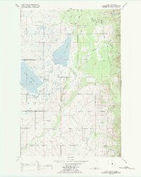
1988 Map of Fort Connah
USGS Topo · Published 1988About this map
The Mission Mountains Tribal Wilderness anchors the eastern edge of this landscape within the Flathead Indian Reservation, where the sharp ascent of the range meets the Mission Valley floor. This 1988 revision illustrates a complex water management system crucial to the region, featuring the expansive Ninepipe Reservoir and Kicking Horse Reservoir. These bodies of water, connected by the Kicking Horse Feeder Canal and numerous unnamed ditches, support both the Ninepipe National Wildlife Refuge and local agriculture.
Find a feature on this map
22 named features on this map. Tap any name to fly to it.
Don’t see what you’re looking for? This feature index may not catch every label — zoom into the map to look around manually.
Map Details
Editions of this 1988 Fort Connah Map
This is the sole edition of this map. No revisions or reprints were ever made.
Other maps of this area

1920 · Flathead Lake
USGS Topo · 1:125,000

1921 · Elbow Lake
USGS Topo · 1:125,000

1955 · Choteau
USGS Topo · 1:250,000

1956 · Wallace
USGS Topo · 1:250,000

1957 · Choteau
USGS Topo · 1:250,000

1958 · Choteau
USGS Topo · 1:250,000

1960 · Wallace
USGS Topo · 1:250,000

1962 · Choteau
USGS Topo · 1:250,000

1964 · Fort Connah
USGS Topo · 1:24,000

1964 · Ronan
USGS Topo · 1:24,000