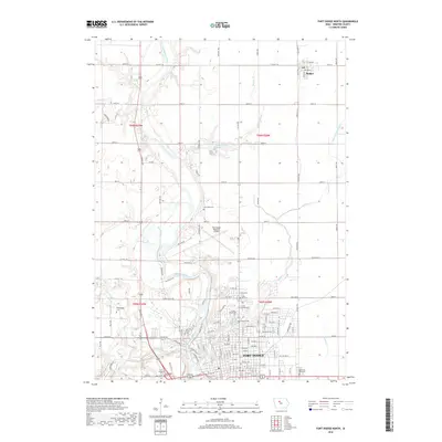
2018 Map of Fort Dodge North
USGS Topo · Published 2018About this map
The Des Moines River winds through this central Iowa landscape, carving a prominent valley that defines the topography north of Fort Dodge. This 2018 survey reveals a transition from the urban grid of the northern city limits to the expansive agricultural sections of the surrounding townships. The northern settlement of Badger sits at the intersection of Co Hwy C56 and 1st Ave NE, serving as a localized hub for the farming community.
Find a feature on this map
71 named features on this map. Tap any name to fly to it.
Don’t see what you’re looking for? This feature index may not catch every label — zoom into the map to look around manually.
Map Details
Editions of this 2018 Fort Dodge North Map
This is the sole edition of this map. No revisions or reprints were ever made.
Other maps of this area

1923 · Lehigh
USGS Topo · 1:62,500

1923 · Fort Dodge
USGS Topo · 1:62,500

1954 · Fort Dodge
USGS Topo · 1:250,000

1957 · Fort Dodge
USGS Topo · 1:250,000

1958 · Fort Dodge
USGS Topo · 1:250,000

1965 · Moorland
USGS Topo · 1:24,000

1965 · Fort Dodge South
USGS Topo · 1:24,000

1965 · Evanston
USGS Topo · 1:24,000
1979 · Fort Dodge North
USGS Topo · 1:24,000
1979 · Thor
USGS Topo · 1:24,000