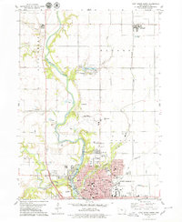
1979 Map of Fort Dodge North
USGS Topo · Published 1979About this map
The Des Moines River carves a deep valley through this northern section of Webster County, creating a dramatic landscape that anchors the industrial and civic life of Fort Dodge. In the late 1970s, the city’s northern expansion is evident, framed by an extensive network of cemeteries including Corpus Christi Cem, Oakland Cem, and North Lawn Cem. The infrastructure of the era is well-defined, from the Fort Dodge Municipal Airport on the plateau to the active North Western and Illinois Central railroad lines that historically drove the local economy. Recreation and education are prominent features of the community fabric, shown through Kennedy Memorial County Park surrounding Badger Lake, the Fort Dodge Country Club, and numerous neighborhood schools like Hawley Sch and Duncombe Sch. The presence of several quarries and a gaging station near Island Park reflects the city's long-standing relationship with its river and mineral resources.
Find a feature on this map
68 named features on this map. Tap any name to fly to it.
Don’t see what you’re looking for? This feature index may not catch every label — zoom into the map to look around manually.
Map Details
Editions of this 1979 Fort Dodge North Map
This is the sole edition of this map. No revisions or reprints were ever made.
Other maps of this area

1923 · Lehigh
USGS Topo · 1:62,500

1923 · Fort Dodge
USGS Topo · 1:62,500

1954 · Fort Dodge
USGS Topo · 1:250,000

1957 · Fort Dodge
USGS Topo · 1:250,000

1958 · Fort Dodge
USGS Topo · 1:250,000

1965 · Moorland
USGS Topo · 1:24,000

1965 · Fort Dodge South
USGS Topo · 1:24,000

1965 · Evanston
USGS Topo · 1:24,000
1979 · Thor
USGS Topo · 1:24,000

1979 · Humboldt
USGS Topo · 1:24,000