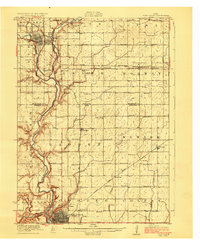
1923 Map of Fort Dodge
USGS Topo · Published 1923About this map
Fort Dodge sits at the confluence of several major rail lines in the early 1920s, serving as a regional hub where the Illinois Central, Chicago Great Western, and St Louis and Minneapolis railroads converge. The landscape is defined by the winding course of the Des Moines River and its numerous tributaries, including Lizard Creek and Deer Creek. This river system dictates the placement of early infrastructure, from the Daniel Boone Trail running along the western bluffs to the settlements of Humboldt and Dakota to the north.
Find a feature on this map
48 named features on this map. Tap any name to fly to it.
Don’t see what you’re looking for? This feature index may not catch every label — zoom into the map to look around manually.
Map Details
Editions of this 1923 Fort Dodge Map
3 editions found
Other maps of this area

1923 · Lehigh
USGS Topo · 1:62,500

1923 · Fort Dodge
USGS Topo · 1:62,500

1954 · Waterloo
USGS Topo · 1:250,000

1954 · Fort Dodge
USGS Topo · 1:250,000

1955 · Waterloo
USGS Topo · 1:250,000

1957 · Fort Dodge
USGS Topo · 1:250,000

1958 · Fort Dodge
USGS Topo · 1:250,000

1965 · Moorland
USGS Topo · 1:24,000

1965 · Fort Dodge South
USGS Topo · 1:24,000

1965 · Evanston
USGS Topo · 1:24,000