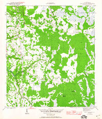
1945 Map of Fort Gadsden
USGS Topo · Published 1960About this map
Fort Gadsden stands as a focal point in this 1940s survey of the Franklin County riverfront, where the land transitions from the dense thickets of Tates Hell Swamp to the banks of the Apalachicola River. The map documents an era of industrial transition in the Florida Panhandle, marked by the remnants of the timber industry and river-based transport. Evidence of former logging operations is scattered across the Apalachicola National Forest, including the Old Logging RR and now-vacant sites such as Walker Camp and Padget Camp. Along the waterways, features like Missouri Landing and Buck Siding reflect a landscape defined by seasonal camps and rail spurs. The intricate drainage network of Whisky George Creek, Hell Branch, and Evans Lake illustrates the complex hydrology that historically challenged movement through this part of the state.
Find a feature on this map
22 named features on this map. Tap any name to fly to it.
Don’t see what you’re looking for? This feature index may not catch every label — zoom into the map to look around manually.
Map Details
Editions of this 1945 Fort Gadsden Map
4 editions found
Other maps of this area

1943 · Jackson River
USGS Topo · 1:24,000

1944 · Green Point
USGS Topo · 1:31,680

1944 · Forbes Island
USGS Topo · 1:24,000

1945 · Forbes Island
USGS Topo · 1:31,680

1945 · Kennedy Creek
USGS Topo · 1:31,680

1945 · Tates Hell Swamp
USGS Topo · 1:31,680

1945 · Beverly
USGS Topo · 1:31,680

1945 · Jackson River
USGS Topo · 1:31,680

1945 · Fort Gadsden
USGS Topo · 1:31,680

1946 · Sumatra
USGS Topo · 1:31,680