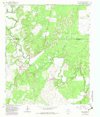
1965 Map of Fort Griffin
USGS Topo · Published 1982About this map
The historical military presence and frontier settlement of Fort Griffin anchor this landscape along the Clear Fork Brazos River. This survey, updated in the early 1980s from mid-century photogrammetric methods, captures the preserved grounds of Fort Griffin State Park, where ruins and a designated Picnic Area sit near the river's bend. The map reflects a quiet rural region defined by its cattle ranching history and early energy exploration, evidenced by numerous Oil Wells and Drill Holes scattered across the limestone hills. Local genealogy is preserved through the locations of the Fort Griffin Cem and Ledbetter Cem, while the winding hydrology of Lambshead Creek and Collins Creek reveals the natural drainages that dictated early ranch boundaries and movement through the Throckmorton and Shackelford County line.
Find a feature on this map
25 named features on this map. Tap any name to fly to it.
Don’t see what you’re looking for? This feature index may not catch every label — zoom into the map to look around manually.
Map Details
Editions of this 1965 Fort Griffin Map
2 editions found
Other maps of this area

1892 · Albany
USGS Topo · 1:125,000

1893 · Albany
USGS Topo · 1:125,000

1954 · Abilene
USGS Topo · 1:250,000

1954 · Wichita Falls
USGS Topo · 1:250,000

1958 · Wichita Falls
USGS Topo · 1:250,000

1958 · Abilene
USGS Topo · 1:250,000

1958 · Edwards Branch
USGS Topo · 1:24,000

1965 · Collins Creek
USGS Topo · 1:24,000

1965 · Lusk
USGS Topo · 1:24,000

1965 · Fort Griffin
USGS Topo · 1:24,000