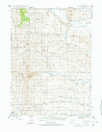
1945 Map of Fort Hill
USGS Topo · Published 1978About this map
Miller Mountain dominates the northwestern corner of this Wyoming landscape, providing a high-elevation backdrop for the network of creeks and irrigation projects that sustained early ranching. Recorded in 1945, the map reveals a rugged western terrain where water management was essential, evidenced by the Howard Canal and numerous ditches flanking La Barge Creek and Fontenelle Creek. These waterways were the lifelines for established family operations, including the Facenelli Ranch, Herschler Ranch, and Jamison Ranch.
Find a feature on this map
25 named features on this map. Tap any name to fly to it.
Don’t see what you’re looking for? This feature index may not catch every label — zoom into the map to look around manually.
Map Details
Editions of this 1945 Fort Hill Map
2 editions found
Other maps of this area

1936 · Cokeville
USGS Topo · 1:96,000

1942 · Cokeville
USGS Topo · 1:125,000

1945 · Fort Hill
USGS Topo · 1:62,500

1947 · Fort Hill
USGS Topo · 1:62,500

1954 · Ogden
USGS Topo · 1:250,000

1954 · Kemmerer
USGS Topo · 1:62,500

1955 · Preston
USGS Topo · 1:250,000

1958 · Ogden
USGS Topo · 1:250,000

1958 · Preston
USGS Topo · 1:250,000

1960 · Ogden
USGS Topo · 1:250,000