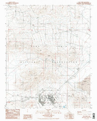
1986 Map of Fort Irwin
USGS Topo · Published 1986About this map
Fort Irwin serves as the central hub within the expansive Fort Irwin Military Reservation, shown here during a period of mid-1980s infrastructure development. The settlement is organized with a concentrated residential and administrative core, supported by specialized facilities including a Heliport, multiple Helipads, and a Picnic Area. To the east, the dry expanse of Bicycle Lake provides the foundation for the Bicycle Lake Army Airfield, while the surrounding terrain is dominated by the peaks of the Tiefort Mts. and the winding path of Coyote Canyon. This provisional survey highlights a landscape of active utility, documenting numerous Observation Towers, a Sanitary Disposal Site, and areas of ongoing Construction. The network of 4wd tracks and improved roads illustrates the desert training environment, providing a detailed look at the base's functional layout before later expansions altered the footprint of these desert facilities.
Find a feature on this map
22 named features on this map. Tap any name to fly to it.
Don’t see what you’re looking for? This feature index may not catch every label — zoom into the map to look around manually.
Map Details
Editions of this 1986 Fort Irwin Map
3 editions found
Other maps of this area

1933 · Avawatz Mountains
USGS Topo · 1:250,000

1947 · Trona
USGS Topo · 1:250,000

1948 · Trona
USGS Topo · 1:250,000

1948 · Alvord Mountain
USGS Topo · 1:62,500

1948 · Lane Mountain
USGS Topo · 1:62,500

1948 · Goldstone Lake
USGS Topo · 1:62,500

1948 · Tiefort Mountains
USGS Topo · 1:62,500

1951 · Goldstone Lake
USGS Topo · 1:62,500

1951 · Tiefort Mountains
USGS Topo · 1:62,500

1951 · Alvord Mountain
USGS Topo · 1:62,500