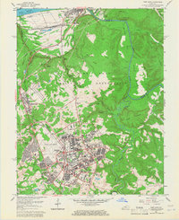
1960 Map of Fort Knox
USGS Topo · Published 1966About this map
The Fort Knox military landscape dominates this 1960 revision, showing the extensive infrastructure of the Fort Knox Military Reservation alongside the historic civilian settlements of West Point and Muldraugh. This mid-century survey details the complex network of barracks, hospitals, and specialized facilities, most notably the U S Bullion Depository and the busy operational layout of Godman Army Airfield. Beyond the military core, the terrain is marked by numerous family burial grounds such as Withers Cem, Boone Cem, and Geoghegan Cem, reflecting the area's deep-rooted pioneer history before the expansion of the post. The confluence of the Ohio River and Salt River at the northern edge remains a focal point for the region's geography, framed by the rail corridors of the Louisville and Nashville and Illinois Central railroads that served both the Army and local industry.
Find a feature on this map
91 named features on this map. Tap any name to fly to it.
Don’t see what you’re looking for? This feature index may not catch every label — zoom into the map to look around manually.
Map Details
Editions of this 1960 Fort Knox Map
Other maps of this area

1909 · Kosmosdale
USGS Topo · 1:48,000

1912 · Kosmosdale
USGS Topo · 1:62,500

1931 · Corydon
USGS Topo · 1:62,500

1936 · Vine Grove
USGS Topo · 1:62,500

1941 · Ekron
USGS Topo · 1:62,500

1943 · Vine Grove
USGS Topo · 1:62,500

1946 · Rock Haven
USGS Topo · 1:24,000

1946 · Pitts Point
USGS Topo · 1:24,000

1946 · Fort Knox
USGS Topo · 1:24,000

1946 · Colesburg
USGS Topo · 1:24,000