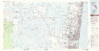
1981 Map of Fort Lauderdale
USGS Topo · Published 1983About this map
The eastern coast of South Florida in the early 1980s reveals a sharp boundary between dense urban development and the immense wilderness of the Everglades. This transition is clearly defined by the massive water control infrastructure of the era, including the Hillsboro Canal, North New River Canal, and South New River Canal. While the coastal strip is heavily populated with cities like Fort Lauderdale, Pompano Beach, and Boca Raton, the western portion of the map is dominated by vast conservation and management zones. These include the Loxahatchee National Wildlife Refuge and the Big Cypress Seminole Indian Reservation.
Find a feature on this map
49 named features on this map. Tap any name to fly to it.
Don’t see what you’re looking for? This feature index may not catch every label — zoom into the map to look around manually.
Map Details
Editions of this 1981 Fort Lauderdale Map
This is the sole edition of this map. No revisions or reprints were ever made.
Other maps of this area

1945 · Fort Lauderdale North
USGS Topo · 1:24,000

1945 · Greenacres City
USGS Topo · 1:24,000

1945 · Lake Worth
USGS Topo · 1:24,000

1946 · West Dixie Bend
USGS Topo · 1:24,000

1946 · Boca Raton
USGS Topo · 1:24,000

1947 · North Miami
USGS Topo · 1:24,000

1947 · Delmar Farms
USGS Topo · 1:24,000

1949 · Lake Worth
USGS Topo · 1:24,000

1949 · Opalocka
USGS Topo · 1:24,000

1949 · Fort Lauderdale North
USGS Topo · 1:24,000