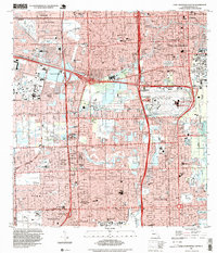
1994 Map of Fort Lauderdale South
USGS Topo · Published 1999About this map
Hollywood Indian Reservation and the sprawling infrastructure of south Florida define this mid-1990s landscape. The map captures the dense urbanization and water-management systems of Fort Lauderdale and Hollywood just before the turn of the millennium. The massive interchange of Floridas Turnpike, I-95, and I-595 serves as a central hub, illustrating the region's reliance on high-capacity transit corridors.
Find a feature on this map
109 named features on this map. Tap any name to fly to it.
Don’t see what you’re looking for? This feature index may not catch every label — zoom into the map to look around manually.
Map Details
Editions of this 1994 Fort Lauderdale South Map
This is the sole edition of this map. No revisions or reprints were ever made.
Other maps of this area

1945 · Fort Lauderdale North
USGS Topo · 1:24,000

1947 · North Miami
USGS Topo · 1:24,000

1949 · Opalocka
USGS Topo · 1:24,000

1949 · Fort Lauderdale North
USGS Topo · 1:24,000

1949 · Port Everglades
USGS Topo · 1:24,000

1949 · Fort Lauderdale South
USGS Topo · 1:24,000

1949 · Pompano Beach
USGS Topo · 1:24,000

1950 · North Miami
USGS Topo · 1:24,000

1956 · Miami
USGS Topo · 1:250,000

1956 · West Palm Beach
USGS Topo · 1:250,000