
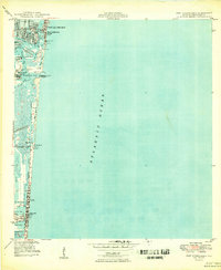
1949 Map of Port Everglades
USGS Topo · Published 1949About this map
Port Everglades and its industrial Turning Basin anchor this late-1940s survey of the Broward County coastline, reflecting a period of post-war maritime expansion. The intricate network of the Intracoastal Waterway and various man-made channels like the Dania Cut-Off Canal and Dania Town Canal illustrate the engineering required to develop these Florida coastal communities. Residential development is visible in the finger islands of Nurmi Isles and along the strips of Fort Lauderdale Beach and Hollywood Beach.
Find a feature on this map
44 named features on this map. Tap any name to fly to it.
Don’t see what you’re looking for? This feature index may not catch every label — zoom into the map to look around manually.
Map Details
Editions of this 1949 Port Everglades Map
2 editions found
Other maps of this area

1945 · Fort Lauderdale North
USGS Topo · 1:24,000

1947 · North Miami
USGS Topo · 1:24,000

1949 · Fort Lauderdale North
USGS Topo · 1:24,000

1949 · Fort Lauderdale South
USGS Topo · 1:24,000

1949 · Pompano Beach
USGS Topo · 1:24,000

1950 · North Miami
USGS Topo · 1:24,000

1956 · Miami
USGS Topo · 1:250,000

1956 · West Palm Beach
USGS Topo · 1:250,000

1957 · West Palm Beach
USGS Topo · 1:250,000

1958 · West Palm Beach
USGS Topo · 1:250,000
Featured Places
- Fort Lauderdale, FL
- Harbor Beach, Fort Lauderdale
- Harbor Heights, Fort Lauderdale
- Nurmi Isles, Fort Lauderdale
- Rio Vista Isles, Fort Lauderdale