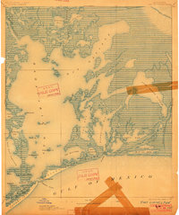
1893 Map of Fort Livingston
USGS Topo · Published 1901About this map
Ft. Livingston stands as the primary landmark on Grande Terre Island, guarding the entrance to Barataria Bay during the late nineteenth century. This coastal survey reveals a landscape almost entirely defined by water and marsh, with an official note indicating the entire area sits less than five feet above sea level. The intricate network of saltwater passages includes Grand Pass and Quatre Bayou Pass, which served as vital maritime conduits between the protected bays and the Gulf of Mexico. Beyond the military fortifications, the map identifies small island clusters like Bird Ids. and Shell Ids., alongside named coastal features such as Pelican Pt. and Pt. Peiro. The cartography captures a complex estuarine system of bayous and basins, including Lake Grande Ecaille and Bay Batiste, long before modern coastal erosion significantly altered these shorelines.
Find a feature on this map
40 named features on this map. Tap any name to fly to it.
Don’t see what you’re looking for? This feature index may not catch every label — zoom into the map to look around manually.
Map Details
Editions of this 1893 Fort Livingston Map
3 editions found
Other maps of this area

1891 · Pointe a La Hache
USGS Topo · 1:62,500

1892 · Barataria
USGS Topo · 1:62,500

1892 · Cheniere Caminada
USGS Topo · 1:62,500

1892 · Quarantine
USGS Topo · 1:62,500

1892 · Creole
USGS Topo · 1:62,500

1892 · Pointe a La Hache
USGS Topo · 1:62,500

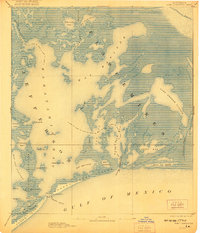
1893 · Fort Livingston
USGS Topo · 1:62,500

1893 · Dime
USGS Topo · 1:62,500

1935 · Port Sulphur
USGS Topo · 1:31,680

1935 · Bastian Bay
USGS Topo · 1:31,680