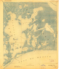
1893 Map of Fort Livingston
USGS Topo · Published 1921About this map
Ft. Livingston and its associated Light stand as the primary human landmark at the threshold between Barataria Bay and the Gulf of Mexico. This coastal landscape, surveyed in the late 19th century, is dominated by an intricate network of marshes, barrier islands, and tidal channels. The boundary between Jefferson and Plaquemines parishes cuts through these waters, which include expansive features like Lake Grande Ecaille and the narrow, winding Bayou St. Denis.
Find a feature on this map
43 named features on this map. Tap any name to fly to it.
Don’t see what you’re looking for? This feature index may not catch every label — zoom into the map to look around manually.
Map Details
Editions of this 1893 Fort Livingston Map
3 editions found
Other maps of this area

1891 · Pointe a La Hache
USGS Topo · 1:62,500

1892 · Barataria
USGS Topo · 1:62,500

1892 · Cheniere Caminada
USGS Topo · 1:62,500

1892 · Quarantine
USGS Topo · 1:62,500

1892 · Creole
USGS Topo · 1:62,500

1892 · Pointe a La Hache
USGS Topo · 1:62,500

1893 · Fort Livingston
USGS Topo · 1:62,500

1893 · Dime
USGS Topo · 1:62,500

1935 · Port Sulphur
USGS Topo · 1:31,680

1935 · Bastian Bay
USGS Topo · 1:31,680