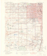
1948 Map of Fort Logan
USGS Topo · Published 1948About this map
Fort Logan and the surrounding institutional landscapes of southwest Denver define this post-war transition, where military reservations and sanatoriums meet expanding residential districts. The area is characterized by a high density of civic and medical landmarks, including the Craig Colony for polio patients and the neighboring Spivak settlement. To the south, the sprawling grounds of Loretto Heights College and the Federal Correctional Institution sit atop the rising terrain overlooking Bear Creek.
Find a feature on this map
75 named features on this map. Tap any name to fly to it.
Don’t see what you’re looking for? This feature index may not catch every label — zoom into the map to look around manually.
Map Details
Editions of this 1948 Fort Logan Map
This is the sole edition of this map. No revisions or reprints were ever made.
Other maps of this area

1890 · East Denver
USGS Topo · 1:125,000

1899 · West Denver
USGS Topo · 1:125,000

1935 · East Denver Nos. 3 and 4
USGS Topo · 1:48,000

1938 · Morrison
USGS Topo · 1:24,000

1938 · Derby
USGS Topo · 1:24,000

1939 · Golden
USGS Topo · 1:24,000

1940 · Englewood
USGS Topo · 1:31,680

1940 · Derby
USGS Topo · 1:31,680

1941 · Arvada
USGS Topo · 1:31,680

1941 · Fort Logan
USGS Topo · 1:31,680