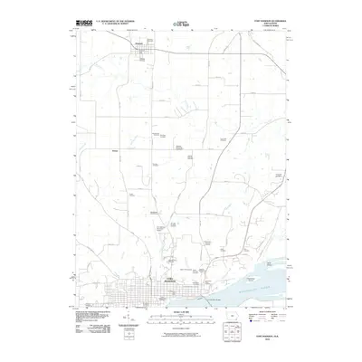
2010 Map of Fort Madison
USGS Topo · Published 2010About this map
Fort Madison anchors the southern edge of this Lee County landscape, where the town’s grid meets the north bank of the Mississippi River. The riverfront is defined by significant landmarks including the Fort Madison Bridge and the large industrial and institutional footprint of the Iowa State Prison Cemetery. Inland, the terrain is characterized by a dense concentration of burial grounds and family plots such as the Mothershed Cemetery, John Box Grounds Cemetery, and Lauther Grounds Cemetery, offering a wealth of data for genealogical researchers. North of the river, the small settlement of Denmark serves as a secondary focal point, complete with its own Denmark Post Office and the Riddles Airstrip. The map also details the complex drainage systems of Lost Creek, Mud Creek, and Penitentiary Creek as they move through the agricultural uplands toward the river valley near Mink Island and Dutchman Island.
Find a feature on this map
71 named features on this map. Tap any name to fly to it.
Don’t see what you’re looking for? This feature index may not catch every label — zoom into the map to look around manually.
Map Details
Editions of this 2010 Fort Madison Map
This is the sole edition of this map. No revisions or reprints were ever made.
Other maps of this area

1932 · Lomax
USGS Topo · 1:62,500

1934 · Burlington
USGS Topo · 1:48,000

1936 · Fort Madison
USGS Topo · 1:62,500

1937 · Lomax
USGS Topo · 1:62,500

1940 · Burlington
USGS Topo · 1:62,500

1958 · Burlington
USGS Topo · 1:250,000

1961 · Burlington
USGS Topo · 1:250,000

1963 · Burlington
USGS Topo · 1:250,000
1964 · Nauvoo
USGS Topo · 1:24,000

1964 · West Point
USGS Topo · 1:24,000