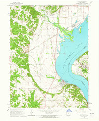
1964 Map of Nauvoo
USGS Topo · Published 1965About this map
The Mississippi River defines the landscape of this mid-1960s survey, separating the community of Nauvoo in Hancock County, Illinois, from Montrose and Viele on the Iowa side. This stretch of the river is marked by industrial and transit activity, with both the Chicago Burlington and Quincy and the Atchison Topeka and Santa Fe railroads running along the banks. An Indian Treaty Boundary line cuts across the northern landscape near Sugar Creek, providing a distinct historical marker of nineteenth-century land division.
Find a feature on this map
42 named features on this map. Tap any name to fly to it.
Don’t see what you’re looking for? This feature index may not catch every label — zoom into the map to look around manually.
Map Details
Editions of this 1964 Nauvoo Map
2 editions found
Other maps of this area

1903 · Kahoka
USGS Topo · 1:125,000

1936 · Keokuk
USGS Topo · 1:62,500

1936 · Fort Madison
USGS Topo · 1:62,500

1949 · Wayland
USGS Topo · 1:24,000

1950 · Wayland
USGS Topo · 1:24,000

1950 · Keokuk
USGS Topo · 1:62,500

1958 · Burlington
USGS Topo · 1:250,000

1961 · Burlington
USGS Topo · 1:250,000

1963 · Burlington
USGS Topo · 1:250,000
1964 · Hamilton
USGS Topo · 1:24,000