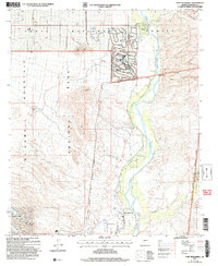
2004 Map of Fort McDowell
USGS Topo · Published 2007About this map
The Verde River serves as the central artery of this Central Arizona landscape, flanked by the residential growth of Rio Verde Estates and Fountain Hills. The river's valley is deeply connected to the indigenous and military history of the region, defined largely by the Fort McDowell Indian Reservation Boundary. Near the banks of the river, the Jones Ditch irrigation system hints at the long-standing agricultural efforts required to sustain life in this arid environment. The map provides a clear distinction between the developed fringes and the protected lands of McDowell Mountain Regional Park and Tonto National Forest. Local history is anchored at Fort McDowell, where the transition from a nineteenth-century military outpost to a tribal community center is physically recorded. Features like Lousley Hill and Asher Hills provide the vertical relief that frames the river basin, while Sycamore Creek and Malpais Canyon mark the complex drainage patterns of the high desert.
Find a feature on this map
16 named features on this map. Tap any name to fly to it.
Don’t see what you’re looking for? This feature index may not catch every label — zoom into the map to look around manually.
Map Details
Editions of this 2004 Fort McDowell Map
This is the sole edition of this map. No revisions or reprints were ever made.
Other maps of this area

1904 · Camelback
USGS Topo · 1:62,500

1904 · Ft. McDowell
USGS Topo · 1:62,500

1906 · Camelsback
USGS Topo · 1:62,500

1906 · Ft. McDowell
USGS Topo · 1:62,500

1930 · Cave Creek
USGS Topo · 1:125,000

1939 · Cave Creek
USGS Topo · 1:125,000

1954 · Mesa
USGS Topo · 1:250,000

1957 · Mesa
USGS Topo · 1:250,000

1958 · Mesa
USGS Topo · 1:250,000

1960 · Mesa
USGS Topo · 1:250,000