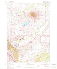
1953 Map of Fort Meade
USGS Topo · Published 1972About this map
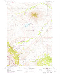
Bear Butte dominates this Black Hills landscape, standing as a prominent landmark north of the Fort Meade Military Reservation. This 1950s era survey, later updated in the early 1970s, documents the transition of the historic cavalry post at Fort Meade into a modern Veterans Hospital complex. The surrounding terrain is marked by the Old Fort Meade Military Bdy and the Bear Butte National Wildlife Refuge, which surrounds Bear Butte Lake. Rural life is evidenced by the distribution of country schoolhouses, including Spring Creek Sch, Hamm Sch, and Carpenter Sch. Near the southwestern edge of the quadrangle, the city of Sturgis sits along the Chicago and North Western railroad line, while the Sturgis Airport serves the local aviation needs. The map captures a detailed hydrographic network including Spring Creek, Alkali Creek, and the curiously named Flowing Well to the southeast.
Find a feature on this map
22 named features on this map. Tap any name to fly to it.
Don’t see what you’re looking for? This feature index may not catch every label — zoom into the map to look around manually.
Map Details
Editions of this 1953 Fort Meade Map
5 editions found
Other maps of this area

1893 · Rapid
USGS Topo · 1:125,000

1894 · Deadwood
USGS Topo · 1:125,000

1898 · Rapid
USGS Topo · 1:125,000

1899 · Sturgis
USGS Topo · 1:62,500

1901 · Deadwood
USGS Topo · 1:125,000

1903 · Rapid
USGS Topo · 1:125,000

1905 · Saint Onge
USGS Topo · 1:62,500

1906 · Vale
USGS Topo · 1:62,500

1907 · Belle Fourche
USGS Topo · 1:125,000

1913 · Newell
USGS Topo · 1:125,000