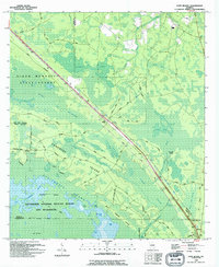
1994 Map of Fort Mudge
USGS Topo · Published 1994About this map
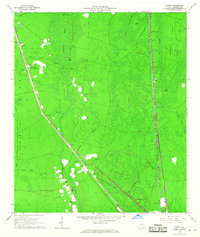
Cowhouse Island emerges from the surrounding wetlands of Ware County, marking a significant geographic feature within the Okefenokee National Wildlife Refuge and Wilderness. This 1994 revision, based on surveys dating back to the late 1960s, documents a landscape where the transition between dry land and swamp is defined by labels such as Cowhouse Poke Bay Swamp and Wide Slough. Human settlement follows the higher ground along the northwestern corridor, where Crews Boulevard connects the small communities of Thrift, Fort Mudge, and Lydia.
Find a feature on this map
52 named features on this map. Tap any name to fly to it.
Don’t see what you’re looking for? This feature index may not catch every label — zoom into the map to look around manually.
Map Details
Editions of this 1994 Fort Mudge Map
This is the sole edition of this map. No revisions or reprints were ever made.
Other maps of this area

1918 · Folkston
USGS Topo · 1:62,500

1953 · Waycross
USGS Topo · 1:250,000

1954 · Valdosta
USGS Topo · 1:250,000

1958 · Valdosta
USGS Topo · 1:250,000

1958 · Waycross
USGS Topo · 1:250,000

1959 · Valdosta
USGS Topo · 1:250,000
1965 · Double Lakes
USGS Topo · 1:24,000
1965 · Dinner Pond
USGS Topo · 1:24,000
1966 · Winokur
USGS Topo · 1:24,000
1966 · Newell
USGS Topo · 1:24,000