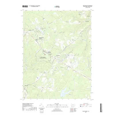
2019 Map of Fort Necessity
USGS Topo · Published 2019About this map
Fort Necessity National Battlefield anchors this study of Fayette County, centered on the intersection of the National Pike and the ridge-top settlements of Farmington and Mount Washington. The landscape is a complex weave of historical memory and modern recreation, featuring the General Edward Braddock Gravesite and numerous small family burial grounds like the Spear Cem and Cromwell Family Cem. The geography is defined by deep hollows and creek systems, including Stony Fork and Meadow Run, which feed into larger bodies such as Heritage Lake and Deer Lake. In the northeast, the terrain drops sharply toward Ohiopyle and the iconic Cucumber Falls. This map illustrates how the ancient travel corridor of the National Pike continues to dictate the placement of communities, churches like the Mount Washington Presbyterian Church, and local infrastructure such as Nemacolin Airport.
Find a feature on this map
114 named features on this map. Tap any name to fly to it.
Don’t see what you’re looking for? This feature index may not catch every label — zoom into the map to look around manually.
Map Details
Editions of this 2019 Fort Necessity Map
This is the sole edition of this map. No revisions or reprints were ever made.
Other maps of this area

1900 · Accident
USGS Topo · 1:62,500

1900 · Uniontown
USGS Topo · 1:62,500

1904 · Bruceton
USGS Topo · 1:62,500

1922 · Confluence
USGS Topo · 1:62,500

1926 · Bruceton
USGS Topo · 1:62,500

1931 · Uniontown
USGS Topo · 1:62,500

1931 · Confluence
USGS Topo · 1:62,500

1931 · Bruceton Mills
USGS Topo · 1:62,500

1933 · Confluence
USGS Topo · 1:62,500

1933 · Bruceton
USGS Topo · 1:62,500
Featured Places
- Farmington, Wharton Township
- Chalkhill, Wharton Township
- North Union Township, PA
- Henry Clay Township, PA
- Wharton Township, PA