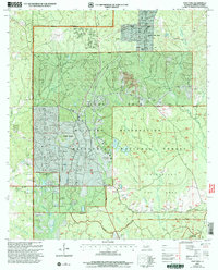
2003 Map of Fort Polk
USGS Topo · Published 2005About this map
The Fort Polk Military Reservation dominates this landscape in Vernon Parish, where a complex network of defense infrastructure and natural watercourses meet. Large areas of the Kisatchie National Forest are designated as intensive use zones, showing the integration of training grounds with the native Louisiana pine woods. Water features like Whisky Chitto Creek, Zourie Bayou, and Bundick Creek drain the terrain, providing natural boundaries within the reservation.
Find a feature on this map
39 named features on this map. Tap any name to fly to it.
Don’t see what you’re looking for? This feature index may not catch every label — zoom into the map to look around manually.
Map Details
Editions of this 2003 Fort Polk Map
This is the sole edition of this map. No revisions or reprints were ever made.
Other maps of this area

1941 · Leesville
USGS Topo · 1:62,500

1941 · Slagle
USGS Topo · 1:62,500

1943 · Leesville
USGS Topo · 1:62,500

1944 · Slagle
USGS Topo · 1:62,500

1946 · Leesville
USGS Topo · 1:62,500

1947 · Rosepine
USGS Topo · 1:31,680

1947 · Chasmore
USGS Topo · 1:31,680

1947 · Sugrue
USGS Topo · 1:31,680

1948 · Leesville
USGS Topo · 1:62,500

1952 · Lake Charles
USGS Topo · 1:250,000
Featured Places
- Fort Polk, Fort Johnson South
- Sandy Hill, LA
- North Fort Polk, LA
- Fort Johnson South, LA
- Vernon Parish, LA