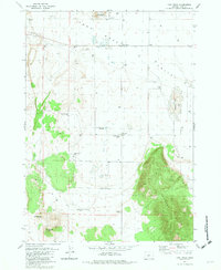
1981 Map of Fort Rock
USGS Topo · Published 1982About this map
Fort Rock State Monument dominates the northern landscape of this Lake County quadrangle, situated within the wider Fort Rock Valley. The map documents a sparsely populated high-desert environment in the late 1970s and early 1980s, where water management is central to the settlement pattern. A network of family-named water sources such as Gauldin Well, Sprague Well, and Thomas Well are scattered across the valley floor, supporting the rural community centered on Fort Rock. The presence of the Community Seeding Well suggests specific agricultural or land-management efforts of the era.
Find a feature on this map
21 named features on this map. Tap any name to fly to it.
Don’t see what you’re looking for? This feature index may not catch every label — zoom into the map to look around manually.
Map Details
Editions of this 1981 Fort Rock Map
This is the sole edition of this map. No revisions or reprints were ever made.
Other maps of this area

1955 · Crescent
USGS Topo · 1:250,000

1957 · Crescent
USGS Topo · 1:250,000

1958 · Crescent
USGS Topo · 1:250,000

1968 · Silver Lake
USGS Topo · 1:24,000

1968 · Oatman Flat
USGS Topo · 1:24,000

1970 · Crescent
USGS Topo · 1:250,000

1979 · Crescent
USGS Topo · 1:100,000

1981 · Cougar Mtn
USGS Topo · 1:24,000
1981 · Tuff Butte
USGS Topo · 1:24,000
1981 · Cabin Lake
USGS Topo · 1:24,000