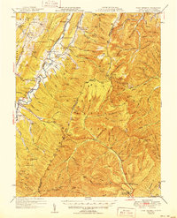
1951 Map of Fort Seybert
USGS Topo · Published 1951About this map
The South Fork Potomac River carves a deep valley through this mid-century survey of the Appalachian Highlands, where the borders of West Virginia and Virginia meet. Small farming communities and post offices like Fort Seybert, Brandywine, and Fame are linked by a network of rural roads and mountain gaps such as Kane Gap and Hiveley Gap. The landscape is dotted with the hallmarks of early 20th-century rural life, including numerous small schoolhouses like Dunkle Sch and Enterprise Sch, alongside country churches including New Bethlehem Ch.
Find a feature on this map
155 named features on this map. Tap any name to fly to it.
Don’t see what you’re looking for? This feature index may not catch every label — zoom into the map to look around manually.
Map Details
Editions of this 1951 Fort Seybert Map
2 editions found
Other maps of this area

1892 · Franklin
USGS Topo · 1:125,000

1892 · Woodstock
USGS Topo · 1:125,000

1892 · Harrisonburg
USGS Topo · 1:125,000

1894 · Staunton
USGS Topo · 1:125,000

1896 · Franklin
USGS Topo · 1:125,000

1920 · Petersburg
USGS Topo · 1:48,000

1920 · Onego
USGS Topo · 1:62,500

1921 · Orkney Springs
USGS Topo · 1:48,000

1921 · Petersburg
USGS Topo · 1:48,000

1921 · Onego
USGS Topo · 1:48,000